Chesapeake Water Watch Virtual Training
Welcome to the Chesapeake Water Watch (CWW)!
This volunteer-powered program seeks to help NASA optimize its satellite algorithms so that they can remotely track the water quality in coastal ecosystems like the Chesapeake Bay. We do this by taking data on the ground and comparing it to the satellite data in a process known as "ground truthing". The Chesapeake Bay is our nation's largest estuary and because of this, we can't accomplish this research without your help.
Thank you so much for taking this first step to becoming a contributor and we are so excited to welcome you to the CWW team!
This virtual training session should take less than 30 minutes and can be taken at any time. Please begin by watching the video below and then going through the content and videos in order.
Check out the tutorials below to get started!
Step 1: Using the HydroColor App
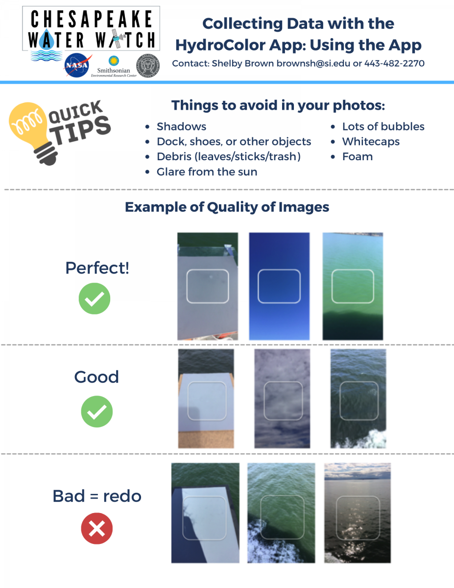
HydroColor is a free, mobile app that can be used to measure the turbidity (how clear or cloudy) of the body of water just by using pictures from your smartphone! In the Chesapeake Water Watch project, the HydroColor data is currently the most useful form of data that volunteers can collect.
Download the app here:
- For iPhone users click here
- For Android users click here
What you will need:
- Smartphone
- Gray card (purchase yours here)
- Clip board (we recommend one like this)
- Long dock or boat (somewhere you can get at least 100 feet from shore)
How to collect data:
To view and download the step-by-step PDF protocol click here.
Summary:
- HydroColor app measurements allow researchers at the Smithsonian Environmental Research Center and The City College of New York to compare turbidity measurements taken on the ground to turbidity measurements from NASA's satellite data.
- HydroColor measurements must be taken at least 100 feet from shore. The satellite data we are looking at have a resolution of 30 meters which is approximately 100 feet. To learn more about the satellites and remote sensing click here.
- It's most helpful to take HydroColor data on clear, sunny days when the satellites pass over, but whenever you're able to get out and collect data is most appreciated! (Find the satellite overpass schedule here)
- It's ideal to collect data in the morning before noon, but any time between 9-11AM and 1-4PM is great.
Some examples of good (and not so good) HydroColor photos:
Step 2: Entering Data in Fieldscope
Fieldscope is the web platform that our researchers use to access the HydroColor data you collect! We strongly support the mission of sharing knowledge so the data you enter on Fieldscope is open for anyone to view and use, not just participants of the Chesapeake Water Watch program!
How to enter your data:
*This video assumes you have already made an account in Fieldscope. Please see the PDF protocol below or watch the video here with exact steps on how to create an account.*
To view and download the step-by-step PDF protocol click here.
Summary:
- If it's your first time collecting data at a location, be sure to create a new station that you will be able to access from the dropdown in the future!
- Be sure to name your station using the following format: Body of water initials_Your initials_Unique identifier that will allow you to identify this station in the future.
- You can find your turbidity data and latitude and longitude data in the HydroColor app by going to the Library and scrolling to the bottom to find your most recent measurements. Select the trial and use the table provided to see all your information.
Step 3: Collecting a Water Sample
Water samples allow us to verify the turbidity data we see from the HydroColor app. Please only collect water samples and deliver them to SERC if you are able to take a sample and deliver it within the same day for us to process. Water samples always have HydroColor data associated with it, but not all HydroColor data requires a water sample each time!
What you will need:
- Empty water bottle with cap (has only ever had water in it, no other liquid)
- Permanent marker
- Small dark cooler, bag, or container
How to collect a water sample:
To view and download the step-by-step protocol PDF click here.
Summary:
- Only use a container that has only ever had water inside it.
- Be sure to store your sample in a cool, dark place (like a small cooler or backpack) when transporting it to SERC. No need to refrigerate it.
- Collect water samples as frequently (or infrequently) as you like!
Directions to SERC Mathias Laboratory drop-off location:
- The Smithsonian Environmental Research Center (SERC) is located at 647 Contees Wharf Road Edgewater, MD 21037.
- Continue straight after security checkpoint until you reach a stop sign and then turn right.
- Continue straight until you reach another stop sign and go straight to the Mathias roundabout.
- The main entrance of the Mathias Laboratory is to the right of the roundabout. Go through the doors and you will see two coolers by the receptionist desk.
- Place your water sample in one of the coolers and scan the QR code to let SERC staff know the sample has been dropped off!
FAQs
HydroColor FAQs:
- What is the best day to collect data?
- Ideally, on clear sky days when satellites are passing over. However, collecting data on any day is welcomed! (Find the satellite overpass schedule here)
- What is the best time of day to collect data?
- It's best to go out in the morning before noon, but anytime between 9-11AM and 1-4PM is good.
- Can I retake a photo for the gray card, sky, or water?
- Yes, you can do this by clicking on the thumbnail outside the capture frame on the "Collect Data" home page
- How do I get the best GPS accuracy?
- Click "Get GPS Fix" and zoom in on the location map to make sure the pin is at the appropriate position. Sometimes it takes a few times of clicking "Get GPS Fix" and zooming in on the map before the location is accurate.
- What do I do if I cannot bend down to take a picture of the gray card?
- You can use a small table or stool to set the gray card on so that it is more elevated. Please be sure that it is weighed down with a clip board or something similar so it does not blow away!
Fieldscope FAQs:
- Why is my data missing a date or time when I collected data?
- Make sure you click "OK" after choosing your data entry time. If you do not click OK, your information will not be saved.
- How do I edit my data entry? I forgot something or I entered information incorrectly.
- How do I delete data entries?
Water Sampling FAQs:
- What should I avoid when collecting a water sample?
- Avoid accidentally collecting wildlife, debris, and do not go out in unsafe weather conditions.
- Is there a specific depth to sample from?
- The depth of the body of water you are sampling from does not matter. However, you do want to make sure you are at least 100 feet from the shore.
- Do we have to collect a water sample?
- Not at all! Water samples help up verify the HydroColor data we are seeing on the smartphones, but you can collect water samples as frequently or as little as you like. The HydroColor data collection is the most important!