Chesapeake Water Watch
Help our scientists collect water quality data in the Chesapeake Bay!
The Chesapeake Water Watch is a joint project between the Smithsonian Environmental Research Center (SERC) and the City College of New York (CCNY). Our researchers are developing new ways to use remote sensing to fill in water monitoring gaps. We're testing these tools in our backyard - the Chesapeake Bay, aka our nation's largest estuary. We are partnering with Riverkeepers and individuals like you to collect data with simple-to-use scientific equipment and smartphone applications. These measurements collected by people on the ground will be used by researchers to help "train" the satellites to accurately monitor the Bay.
The project results will not only help us monitor the health of the Chesapeake Bay, but will lead to better tools by which to monitor coastal waters around the world!
If you want to receive project announcements, results, and training opportunities, sign up for our mailing list or visit our Get Involved page to find out more ways to participate in the project!
Chesapeake Water Watch is made possible by the NASA Citizen Science for Earth Systems Program (CSESP). Find out more about citizen science and volunteering at NASA.
Get Involved

Get trained and start collecting data!
Sign up for an in-person or virtual training session
Sign up for our eNews!
Receive updates, results, and learn about training opportunities
Inquire about other ways to get involved!
Reach out to the Chesapeake Water Watch Project Manager.

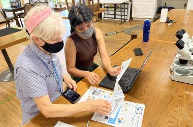
Project volunteer, Sharon Hensley, and previous project coordinator, Shelby Brown, check their study location on the Rhode River to see if it's clear to collect data.

Summer '22 intern, Elizabeth Ramos, and volunteer, Sharon Hensley, enter their data into our online database Fieldscope.


Ways to Get Involved
CWW Virtual Training Sign Up
Sign Up for the Chesapeake Water Watch Email List
The best way to receive updates, results, and learn about training opportunities for the project is to sign up for our email list!
If you have any questions contact Chesapeake Water Watch's Project Manager, Rachel Terracina at TerracinaR@si.edu.
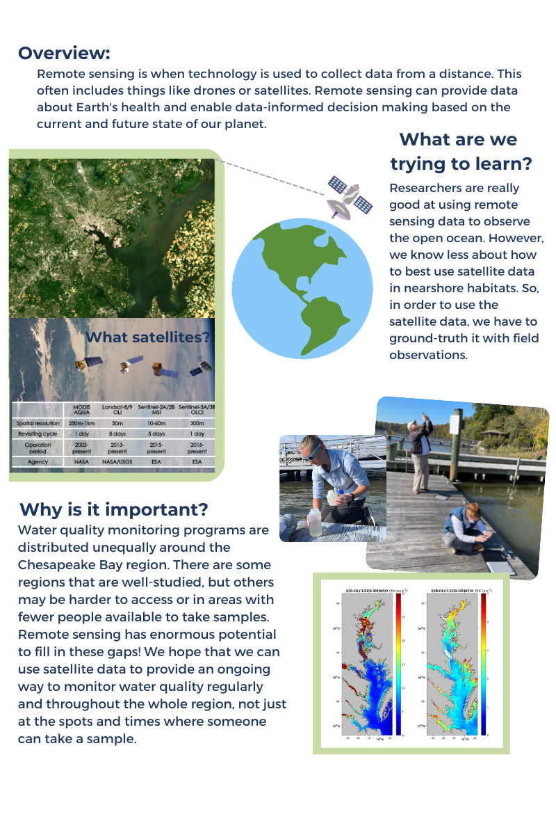
Chesapeake Water Watch: Satellites & Samples
Chesapeake Water Watch: Satellites & Samples
Two of our satellites pass over the Bay on the same day!
Calling all adventurers and volunteer scientists! Prepare for an extraordinary opportunity to contribute to the Chesapeake Water Watch program (funded by NASA). On July 14th, 2023, two high-resolution satellites, Landsat-9 and Sentinel-2a, will soar over the Chesapeake Bay. Help improve water quality monitoring algorithms by collecting a bottle of water, filling out a quick datasheet, and dropping it off at a nearby collection hub. Your small act can make a big impact on protecting our coastal ecosystems. Join us on this exciting quest for scientific discovery and a sustainable future!
Time
Drop-off samples between 9AM - 5PM. Samples must be dropped off at the collection hubs by 5PM (unless otherwise noted) to ensure we have enough time to transport and process the samples.
What You'll Need
An empty plastic water bottle
A smartphone or device to record GPS coordinates
Event datasheet (or piece of paper to record data)
Collection Hubs
Smithsonian Environmental Research Center
647 Contees Wharf Road,
Edgewater, MD 21037
Drop-off window: 8AM - 5PM
Marshy Point Nature Center
7130 Marshy Point Rd,
Middle River, MD 21220
Drop-off window: 9AM - 3PM
Eastern Shore Collection Hub
42 Prospect Bay Dr. W,
Grasonville, MD, 21638
Drop-off window: 9AM - 5PM
Cooler will be on front porch. Knock or ring doorbell to notify drop-off.
Advocates for Herring Bay
404 Arundel Road,
Tracys Landing, MD, 20779
Drop-off window: 9AM - 5PM
Cooler will be on front porch. Knock or ring doorbell to notify drop-off.
Baltimore Rowing & Water Resource Center
3301 Waterview Ave,
Baltimore, MD 21230
Drop-off window: 9AM - 3PM
How To
Click on the image to view the PDF version
CWW Virtual Training: Collecting a Water Sample
For drop-off locations that are not at SERC, you may stop the video at 1:44.
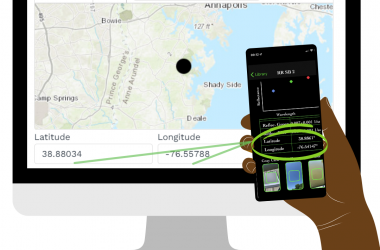
Get GPS Coordinates on Google Maps and Apple Maps
Google Maps
Android
- On your Android phone or tablet, open the Google Maps app
.
- Touch and hold an area of the map that isn’t labeled to drop a red pin.
- In the search box, you can find the coordinates.
iPhone or iPad
- On your iPhone or iPad, open the Google Maps app
- Touch and hold an area of the map that isn’t labeled to drop a red pin.
- At the bottom, tap Dropped pin to find the coordinates.
Apple Maps
Get GPS Coordinates in Maps on iPhone and iPad
Open Maps on your iPhone or iPad and then follow these steps to get your current location’s GPS coordinates.
- Tap the current location button on the top right.
- When the blue circle for your spot appears on the map, tap it.
- Swipe up from the bottom to view full details for your location and you’ll see the Latitude and Longitude.
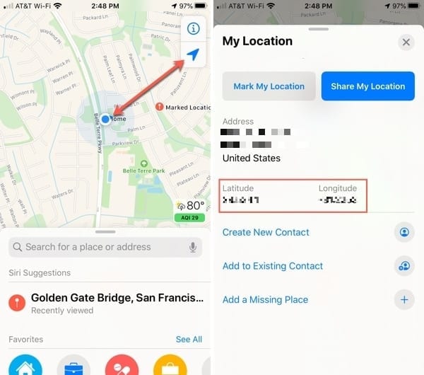
Credit: AppleToolBox
Collection Tips
- Your safety is our #1 priority. If weather does not permit for collection, that’s okay! We will have more events and ways to get involved in the future.
- Be sure to write clearly on your datasheet! We need to be able to match up the water sample to the data on your datasheet. Without both, we won’t be able to use your sample!
- Try to take a water sample as far from the shore as possible. If it’s too close to shore, wave action may contaminate the sample and not give us an accurate representation of the overall body of water.
The Satellites
Long Description
Attention, adventurers and volunteer scientists! Get ready for an extraordinary opportunity to make a splash in the groundbreaking Chesapeake Water Watch program! Brace yourselves as two high-resolution satellites, the incredible Landsat-9 and Sentinel-2a, prepare to soar across the skies above the majestic Chesapeake Bay on a remarkable day—July 14th, 2023!
What's the buzz all about, you ask? Well, the Chesapeake Water Watch program is on a mission to revolutionize water quality monitoring by harnessing the immense power of these cutting-edge satellites. Their ultimate goal? To enhance remote sensing algorithms and accurately decipher the secrets of coastal estuaries and waterways.
Now, hold onto your hats because here comes the exciting part: YOU have the golden opportunity to contribute to this ground-breaking NASA-funded project! Yes, you heard that right! Even if you have an ordinary, run-of-the-mill empty water bottle lounging around, it can become a catalyst for scientific discovery!
So, grab that bottle and prepare to embark on an epic quest to gather crucial data that will shape the future of water quality monitoring. All you need to do is fill out a quick, easy-peasy datasheet with essential information about the water source, such as location and any observations you make. Then, it's time to unleash your inner explorer and drop off your bottle and datasheet at a conveniently located collection hub.
Imagine the thrill of knowing that your simple act of contributing a bottle of water could pave the way for groundbreaking advancements in scientific understanding! You'll be playing a vital role in NASA's quest to protect our precious water resources and safeguard the delicate balance of our coastal ecosystems.
But that's not all! By joining the Chesapeake Water Watch program, you'll be part of a vibrant community of like-minded individuals who share your passion for exploration and scientific discovery. You'll have the opportunity to connect with fellow adventurers, exchange knowledge, and become a champion for the preservation of our environment.
So, let's dive into action! July 14th, 2023, will be a day to remember. Grab your empty water bottle, channel your inner scientist, and embark on an incredible journey to contribute to NASA's Chesapeake Water Watch program. Together, we can make a difference and pave the way for a brighter, more sustainable future for our planet. Get ready to make waves!
Learn more about the Chesapeake Water Watch project
Email Shelby Brown, Chesapeake Water Watch Project Specialist

Click on the image to view the PDF version
Satellites & Samples Event FAQ
1. Why are we collecting water samples?
Water samples are being collected so that the Chesapeake Water Watch program can “ground truth” or optimize NASA satellite algorithms to accurately monitor water quality conditions in the Chesapeake Bay. Using remote sensing as a monitoring tool will help to fill in any monitoring gaps and provide predictions of any major ecological events occurring in the Bay.
2. What will happen to my water sample?
Once it’s dropped off at a collection hub, your water sample will be processed by our team (or partners) using a couple of different benchtop machines. One machine, the turbidimeter, measures water clarity or how “mixed up” the water sample is. The turbidity is important to track, because if a water sample is too turbid sunlight cannot penetrate through the water column and submerged aquatic vegetation (SAV) or seaweed cannot grow. This seaweed naturally filters the water and provides important nursery habitat for various creatures. The other machine that samples will be processed on is an AquaFluor. The AquaFluor provides an in vivo chlorophyll and color dissolved organic matter (CDOM) estimate. We use the in vivo chlorophyll reading to track the amount of “plant-like” matter in the water and any algal blooms that might be forming. CDOM is a good proxy for dissolved carbon, a vital resource for aquatic life but if levels are too high or too low can cause many issues for sustaining a healthy environment.
3. Why does it matter that two satellites are passing over on the same day?
Unlike other satellites, the high-resolution satellites that Chesapeake Water Watch uses only pass over every 5-8 days. For two of the satellites to match up on the same day means double the amount of imagery for us to compare samples with!
4. Where can I collect water from?
The Chesapeake Water Watch primarily focuses on the less-studied rivers and tributaries connecting to the main part of the Chesapeake Bay. Don’t sample from streams, which are typically smaller, shallower, and not useful for the project because satellites can’t see them very well.
When you sample, try to get 100 feet away from shore (on a dock or boat). If you don’t know the specific body of water you are sampling from, just write the latitude and longitude on your water bottle.
5. Can I use any water bottle?
You can use any empty water bottle that has only held water before. Be sure not to use any bottles that have held other liquids.
6. How much water do I need in the water bottle?
Please fill up the water bottle all the way.
7. Where do I drop off my water bottle?
At one of the collection hubs listed on our webpage.
8. When do I need to drop off my water bottle?
Please drop off your water sample on the same day that it was collected. Some collection hubs are accepting samples from until 5PM but some are only accepting samples until 2PM. Be sure to double check the drop-off windows for your chosen collection hub.
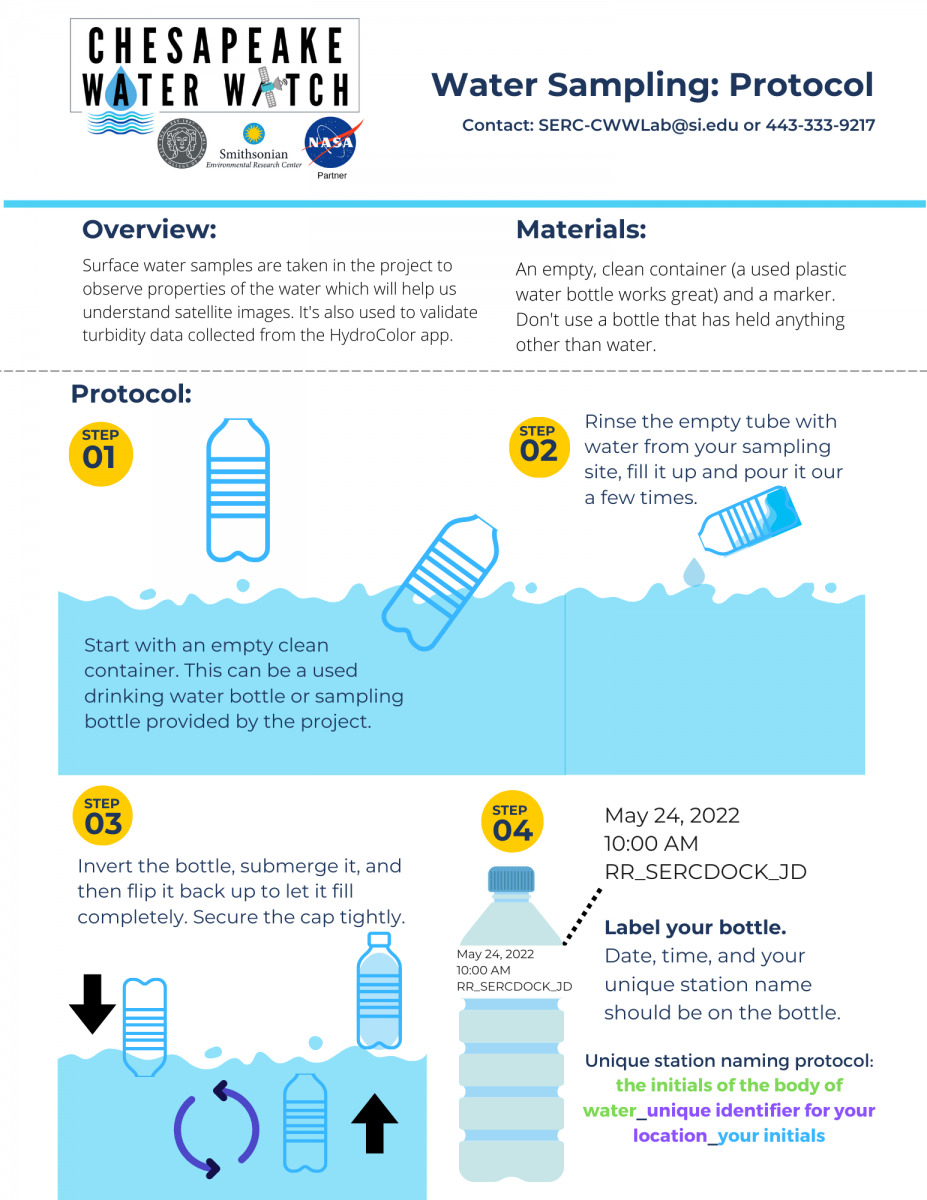
9. How do I label my water bottle?
Write the date, time, and your unique station name on the bottle. The unique station name will be the first two initials of the body of water_a unique name of the station_your initials. Ex. Jane Doe samples on the Rhode River at her pier. She would name her sample, RR_JanesPier_JD. You can also put the latitude and longitude on the bottle instead of a unique name.
10. Can I see the data from the water quality analysis of my water bottle?
Yes! Not only will you receive an email with the results of the collection day, but all data will be uploaded to our open-access database on serc.fieldscope.org.
Chesapeake Water Watch is a joint project between the Smithsonian Environmental Research Center (SERC) and the City College of New York (CCNY) and is funded by NASA. Our team’s researchers are developing new ways to use remote sensing to fill in water monitoring gaps.
We’ve prepared answers to a list of frequently asked questions (FAQ). If your question isn’t answered, visit the Chesapeake Water Watch page to learn more or contact Rachael Mady at madyr@si.edu.
Dock Map
Use our interactive map below to find docks near you to sample from!
- Step 1: Enter your city in the search bar located at the top of the map. The map will zoom into that city. You can also click anywhere on the map to drop a pin on your desired location.
- Step 2: Select your radius (how far you are willing to travel) by using the dropdown below the search bar from step 1.
- Step 3: Click on the gray-outlined dot (or the red dot if you dropped your own pin) on the map to see a list of docks near you within the radius you selected in step 3. If you would like to change your radius, select another distance from the dropdown in step 2 and repeat step 3.
- Step 4: Click on the dock name that you are interested in to view more information and get its physical address. You can then click on the magnifying glass in the lower left corner to zoom to this dock on the map.
Chesapeake Water Watch: Satellites & Samples
Chesapeake Water Watch: Satellites & Samples
Two of our satellites pass over the Bay on the same day!
Attention all adventurers and volunteer scientists! The excitement was so incredible during our last collection event that we just couldn't resist doing it all over again on October 2nd, 2023.
Prepare for another extraordinary opportunity to contribute to NASA's Chesapeake Water Watch program. Once more, we'll have two high-resolution satellites, Landsat-9 and Sentinel-2a, gracing the skies above the Chesapeake Bay.
Join us once more on this exhilarating quest for scientific discovery and a sustainable future! It's as simple as collecting a bottle of water, filling out a quick datasheet, and dropping it off at a nearby collection hub. Your small act can still make a big impact in safeguarding our coastal ecosystems. Don't miss out on the fun!
*Time
Drop-off samples between 9AM-5PM (unless otherwise noted in the collection hub description). Samples must be dropped off at the collection hubs by the time indicated to ensure we have enough time to transport and process the samples.
What You'll Need
An empty plastic water bottle
A smartphone or device to record GPS coordinates
Event datasheet (or piece of paper to record data)
A rubber band or something to attach datasheet to sample bottle
Collection Hubs
Smithsonian Environmental Research Center
Day-of contact: Tara Sill (sillt@si.edu)
647 Contees Wharf Road,
Edgewater, MD 21037
Drop-off window: 8AM - 5PM
Please note that this is subject to change - Be on the lookout on Sunday, Oct. 1st, 2023 for the final location.
Anne Arundel Community College
Day-of contact: Tara Sill (sillt@si.edu)
101 College Parkway,
Arnold, MD 21012
Drop-off window: 9AM - 5PM
Marshy Point Nature Center
Day-of contact: Shelby Brown (443-482-2270)
7130 Marshy Point Rd,
Middle River, MD 21220
Drop-off window: 10AM - 3PM
Eastern Shore Collection Hub
Day-of contact: Shelby Brown (443-482-2270)
9104 Mallard Point Ct
McDaniel MD 21647
Drop-off window: 10AM - 5PM
Cooler will be on front porch. Scan QR code to notify drop-off.
Advocates for Herring Bay
Day-of contact: Tara Sill (sillt@si.edu)
404 Arundel Road,
Tracys Landing, MD, 20779
Drop-off window: 9AM - 5PM
Cooler will be on front porch. Knock or ring doorbell to notify drop-off.
How To
Click on the image to view the PDF version
CWW Virtual Training: Collecting a Water Sample
For drop-off locations that are not at SERC, you may stop the video at 1:44.
Get GPS Coordinates on Google Maps and Apple Maps
This is very important! Accurate GPS points are required for successful data analysis. No GPS location = We can’t use the data!
Google Maps
Android
- On your Android phone or tablet, open the Google Maps app
- Touch and hold an area of the map that isn’t labeled to drop a red pin.
- In the search box, you can find the coordinates.
iPhone or iPad
- On your iPhone or iPad, open the Google Maps app
- Touch and hold an area of the map that isn’t labeled to drop a red pin.
- At the bottom, tap Dropped pin to find the coordinates.
Apple Maps
Get GPS Coordinates in Maps on iPhone and iPad
Open Maps on your iPhone or iPad and then follow these steps to get your current location’s GPS coordinates.
- Tap the current location button on the top right.
- When the blue circle for your spot appears on the map, tap it.
- Swipe up from the bottom to view full details for your location and you’ll see the Latitude and Longitude.
Credit: AppleToolBox
Not sure where to go?
Collection Tips
- Your safety is our #1 priority. If weather does not permit for collection, that’s okay! We will have more events and ways to get involved in the future.
- Be sure to write clearly on your datasheet! We need to be able to match up the water sample to the data on your datasheet. Without both, we won’t be able to use your sample!
- Try to take a water sample as far from the shore as possible. If it’s too close to shore, wave action may contaminate the sample and not give us an accurate representation of the overall body of water.
The Satellites
Methods
The scientific process that the Chesapeake Water Watch project uses is called "ground truthing". As its name suggests, what we are doing is taking data here on the ground to correct and validate the data that satellites are reporting. By taking data on the ground and cross-referencing it with the information provided by the satellites, we are able to essentially "train" the satellites on how to analyze water quality conditions in the Chesapeake Bay. There are three "tiers" of data collection to get involved with. Volunteers can choose from any combination of these tiers and how involved they would like to be with the project! We recommend that data is collected on a day when a satellite is passing over, you can find the Google calendar for satellite flyovers here or at the bottom of this page.
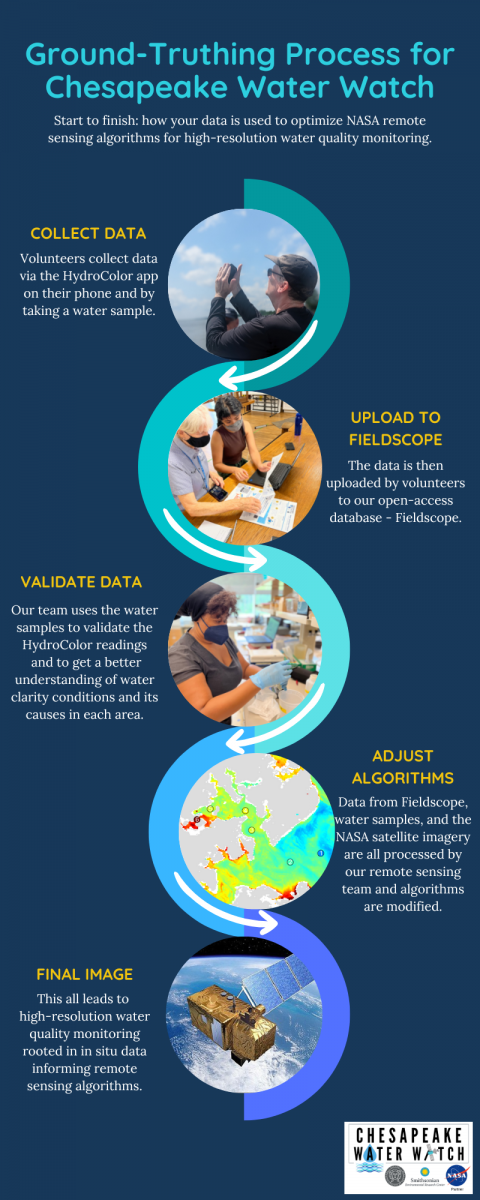
Data Collection
Tier 1 - HydroColor Data
The first level of data collection uses the free, smartphone app - HydroColor. HydroColor requires volunteers to go at least 100 feet from the shoreline and take 3 pictures within the app. The first picture is of a gray card to calibrate the app, the second is a photo of the sky, and the third picture is a picture of the water. The app reads the reflectance of all 3 of the photos and gives a turbidity (or water clarity) reading. That turbidity number is then uploaded to our open-access database Fieldscope where our researchers (and the public!) can access the water quality data from different volunteers around the Bay.
Tier 2 - HydroColor + Small Water Samples
The second level of data collection for the Chesapeake Water Watch project includes taking HydroColor data on a smartphone as well as taking small water samples (about half the size of a water bottle). This water sample is processed back in the lab with small, easy-to-use machines that analyze turbidity (water clarity), color-dissolved organic matter (CDOM), and in vivo chlorophyll (indicator of "plant-like" material/algae in the water). Volunteers even have the opportunity to come in to our lab and process the water samples that they collected themselves before uploading their data to Fieldscope.
Tier 3 - HydroColor + Large Water Samples
The third level of data collection includes taking HydroColor data as well as large water samples (the size of a 12 fl oz water bottle or more). This water sample is processed on the smaller machines in the lab as well as processed by our staff on more advanced machines known as a spectrophotometer and a fluorometer. While volunteers are welcome to process water samples on the smaller machines in the lab, we cannot have volunteers using the spectrophotometer and fluorometer without prior experience with the machines and proper training.
Data Analysis
After the data is collected and reported to Fieldscope, our remote sensing team analyzes the information from the satellite data and cross-references the data collected by our volunteers. The satellite algorithms are adjusted based on the actual data from the Bay.
Satellite Calendar
Data collected any day is useful, but there are certain days when one, or both, of the satellites we work with are passing over the bay. By collecting data on these days, your sample goes the extra mile! Refer to the calendar below to see when each satellite is passing over the bay.
Chesapeake Water Watch: Most Up-to-Date Protocols


Sample Collection Events
Sample Collection Events
Volunteers can collect samples for the Chesapeake Water Watch any day of the year, but sometimes we host special collection events. During these events, we highlight days where data makes an extra impact. On these days we often offer special sample drop-off hours, open additional testing sites, and test all the samples for you (even at self-testing locations!).
To more about upcoming events and how to take samples, keep scrolling!
Upcoming Collection Events
HydroColor Collection Day: May 24th, 2025, June 13th, 2025, July 3rd, 2025,
Grab your gray card and head out to your favorite dock! HydroColor Collection days are great ways to collect data for the Chesapeake Water Watch while there is a satellite overhead! Don't forget to upload your observations to FieldScope so the whole CWW community can see your findings.
*Note: Water samples can still be collected and testing at the standard testing locations (see below) during their normal hours
You'll need a:
- CWW Datasheet
- An 18% Photography Gray Card
- A clipboard (optional, but recommended)
- A smart phone with the HydroColor App downloaded
To learn how to take a HydroColor Sample, you can watch this training video.
Satellites and Samples: April 14th, 2025, August 12th, 2025 (Click on dates to learn more)
There will be two high-resolution satellites, Landsat-9 and Sentinel-2a, gracing the skies above the Chesapeake Bay. We can use your water samples to improve the water quality monitoring algorithms for not one but two satellites.
Getting involved is as easy as 1,2,3! :
- Collect a water and/or HydroColor sample from the Bay or from any tidal river that flows into the Bay
- Fill out a quick data sheet
- Drop off your sample at a nearby collection hub
Your small act can make a big impact in monitoring our coastal ecosystems. Don't miss out on the fun!
What You'll Need for Water Collection Events
An empty plastic water bottle
A smartphone/device to record GPS coordinates
CWW Datasheet (or piece of paper to record data)
A rubber band (or something similar) to attach datasheet to sample bottle
Common Collection Hubs
*For Collection Events: check the "Events Page" for the most accurate information about drop-off locations *
Please note: During collection events, most "self-testing" sites become drop-off locations
Smithsonian Environmental Research Center
Contact: Ray Terracina (TerracinaR@si.edu)
647 Contees Wharf Road,
Edgewater, MD 21037
Drop-off window: 8AM - 3PM
Press red button above cooler to notify of drop-off.
Anne Arundel Community College
Contact: Tammy Domanski (tldomanski@aacc.edu)
101 College Parkway,
Arnold, MD 21012
(443) 994-9236
Drop-off window: 9AM - 3PM
Before dropping off a sample, please text (443) 994-9236 to confirm avaibility. Once dropped off, scan QR code to notify drop-off.
Marshy Point Nature Center
*SELF TESTING LOCATION*
Contact: Ray Terracina (TerracinaR@si.edu)
7130 Marshy Point Rd,
Middle River, MD 21220
Testing window: 9AM - 4:30PM
Enter the classroom on the left, walk to the back corner with cabinets to find the CWW machines and protocol binder. Follow step by step instructions to test your sample. Send a photo of completed data sheet to Ray at TerracinaR@si.edu or upload results directly into Fieldscope.
The Ryan Resilience Lab
*SELF TESTING LOCATION*
Contact: Ray Terracina (TerracinaR@si.edu)
4610 Colley Ave.
Norfolk, VA, 23508
Drop-off window: 9AM - 4PM
Head in through the front door and let the person at the front desk know you are testing or dropping off a Chesapeake Water Watch Sample. If dropping off for a collection event, scan the QR code to notify us you dropped off a sample.
How To
Click on the image to view the PDF version
CWW Virtual Training: Collecting a Water Sample
For drop-off locations that are not at SERC, you may stop the video at 1:44.
Get GPS Coordinates on Google Maps and Apple Maps
This is very important! Accurate GPS points are required for successful data analysis. No GPS location = We can’t use the data!
Google Maps
Android
- On your Android phone or tablet, open the Google Maps app
- Touch and hold an area of the map that isn’t labeled to drop a red pin.
- In the search box, you can find the coordinates.
iPhone or iPad
- On your iPhone or iPad, open the Google Maps app
- Touch and hold an area of the map that isn’t labeled to drop a red pin.
- At the bottom, tap Dropped pin to find the coordinates.
Apple Maps
Get GPS Coordinates in Maps on iPhone and iPad
Open Maps on your iPhone or iPad and then follow these steps to get your current location’s GPS coordinates.
- Tap the current location button on the top right.
- When the blue circle for your spot appears on the map, tap it.
- Swipe up from the bottom to view full details for your location and you’ll see the Latitude and Longitude.
Credit: AppleToolBox
Not sure where to go?
Collection Tips
- Your safety is our #1 priority. If weather does not permit for collection, that’s okay! We will have more events and ways to get involved in the future.
- Be sure to write clearly on your data sheet! We need to be able to match up the water sample to the data on your datasheet. Without both, we won’t be able to use your sample!
- Try to take a water sample as far from the shore as possible. If it’s too close to shore, wave action may contaminate the sample and not give us an accurate representation of the overall body of water.
- Transport your water sample in a cooler or thick bag. Some of the measurements we get from water samples can be affected by heat and light.
The Satellites
Data

Data Collected by Volunteers
Data collected by citizen scientists is crucial for our project. Citizen scientists can help by collecting data from lots of places around the Bay. We'll use the data to ground truth and optimize the algorithms that we use to process the satellite data. Having lots of samples from lots of places allows us to have the best possible data to do this. Check out where data is being collected HERE.
Satellite Data

Satellite image of Chesapeake Bay taken 10/07/22 by Sentinel-2A satellite

Satellite image of Chesapeake Bay taken 02/01/22 by Landsat-OLI9 satellite

Satellite image of Chesapeake Bay taken 08/13/22 by Sentinel-2B satellite


Tips for Data Collection
Don't see your question answered here? Contact CWW Project Manager, Ray Terracina (TerracinaR@si.edu).
FAQs when collecting data using the HydroColor App:
When can I make observations with the HydroColor app?
Any day is a great day to collect data! All data is good data, and your reports are always helpful. As long as the sun is high enough in the sky to avoid direct reflection from the water, you can collect data.
- During the winter, the best window for observations is 9AM - 3PM.
- During the spring and autumn, the best window is 10AM - 4PM.
- During summer, the best window is 9AM - 5PM.
When the sun is too high in the sky, the scattering of light off of the surface of the water can also cause issues with the app. Avoid making observations around 12 when the sun is directly overhead.
What are the best days and times to collect data?
That said, the best times are on clear sky days within one hour of when our project's partner satellites pass overhead.
There are three satellites with which our project coordinates:
Landsat 8/9 and Sentinel-2 fly over around 11AM during the winter or 12PM during the summer. Sentinel-3 also makes daily passes overhead, crossing the Chesapeake Bay at 10AM during the winter and 11AM during the summer. Data collected by Sentinel-3 can only be compared to water sample measurements that are taken at least 1/4 mile from land. Generally, this requires sampling water in the middle of larger rivers and in the main stem of the Bay.
Click here for the satellite calendar!
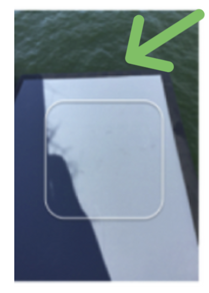
Can I retake a photo for the gray card, sky, or water?
- Yes, you click on the thumbnail outside the capture frame in the main menu (the one that shows all three pictures).
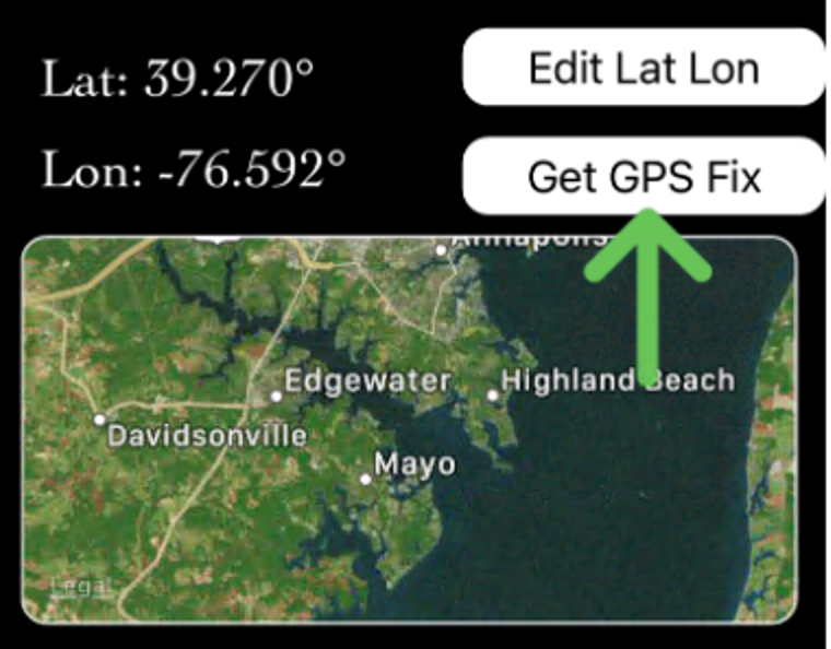
How do I get the best GPS accuracy on the iPhone?
- First, click “Get GPS Fix”. Then zoom in on the location map and make sure the “pin” is in the right position. If it looks not accurately placed, press “Get GPS Fix” again. Re-check your position. You may need to do this each time you start a new (replicate) collection series.
FAQs when entering or looking at data using Chesapeake Water Watch Fieldscope site:
How do I sign up for a Fieldscope account?
How do I enter data?
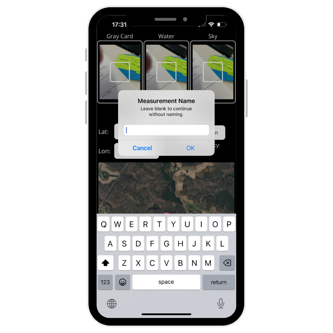
Why is my data entry missing a date or time when I collected data?
- Make sure you click OK after choosing your data entry time. If you do not click OK, your information will not be saved.
How do I edit my data entry? I forgot something or I entered information incorrectly.
How do I delete data entries?
- Click "Data" from the top menu.
- Make sure you are looking at the data you entered in "table" form.
- Click on the data entry you would like to remove. A side menu should appear.
- In the side menu that appeared, there is a "Review" button, click that.
- A box will appear that says "Leave a note for the project managers on why this data needs to be reviewed." Enter the reasoning why this data should be deleted or removed.
- Click submit. The project managers will review and delete the data entry if they feel it's necessary.
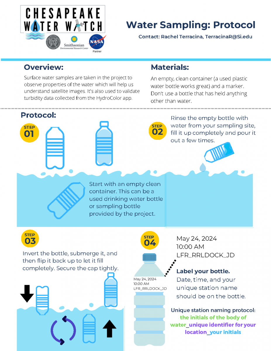
Sample Naming Protocol
This guide will tell you how to label your HydroColor observations, your water samples, and your stations in Fieldscope. Use the Chesapeake Water Watch River/Bay Naming Abbreviations table at the bottom of the page to find the initials associated with the body of water you sampled.
HydroColor
Enter: the initials of the body of water_unique identifier for your location_your initials_the measurement number
For example: this is Jane Doe's first measurement on the Rhode River at her pier, so her entry will read: RR_JanesPier_JD_1
Water Sample

Label your bottle.
Date, time, and your unique station name should be on the bottle.
Unique station naming protocol: the initials of the body of water_unique identifier for your location_your initials
Fieldscope Station Name
Unique station naming protocol: the initials of the body of water_unique identifier for your location_your initials
For example: Jane Doe is sampling the Rhode River off their pier so they are naming the station RR_JanesPier_JD

Use our interactive map below to find docks near you to sample from!
- Step 1: Enter your city in the search bar located at the top of the map. The map will zoom into that city. You can also click anywhere on the map to drop a pin on your desired location.
- Step 2: Select your radius (how far you are willing to travel) by using the dropdown below the search bar from step 1.
- Step 3: Click on the gray-outlined dot (or the red dot if you dropped your own pin) on the map to see a list of docks near you within the radius you selected in step 3. If you would like to change your radius, select another distance from the dropdown in step 2 and repeat step 3.
- Step 4: Click on the dock name that you are interested in to view more information and get its physical address. You can then click on the magnifying glass in the lower left corner to zoom to this dock on the map.
Chesapeake Water Watch River/Bay Naming Abbreviations
Results
Check out the results from Chesapeake Water Watch's first peer-reviewed publication!
The core project team, led by research scientist Patrick Neale, analyzed the data (collected by people like you!) and translated the results into a story for a peer-reviewed scientific publication. Thank you so much to 104+ people who's observations made this paper possible! A special shout out to volunteer Beth Paquette, one of the paper's co-authors.
We've summarized highlights from the paper below. You can also check out the full publication and download it from the open-access PLOS One Journal.
Project Team
Current
Patrick Neale, PhD has been a research scientist at Smithsonian Environmental Research Center since 1993 supervising the Photobiology and Solar Radiation laboratory. His research focuses on the effects of sunlight, especially ultraviolet radiation, on aquatic ecosystems. Neale received a B.A. in Environmental Studies from SUNY Purchase College, M.A. in statistics at Columbia University and Ph.D. in aquatic ecology at the University of California, Davis.
Alison Cawood, PhD is the Director of Public Engagement at the Smithsonian Environmental Research Center (SERC). In this role, she oversees SERC’s environmental education, Participatory Science, and professional training programs, and works to make SERC science relevant and accessible to a wide range of audiences. Alison earned her Ph.D. in Oceanography from Scripps Institution of Oceanography, University of California, San Diego. She earned bachelors’ degrees in Marine Biology and Hispanic Studies from the College of Charleston.
Maria Tzortziou, PhD (Project Institutional PI) is a Professor of Environmental Sciences supervising the Bio-Optics laboratory at the Center for Discovery and Innovation of The City College of New York, and Research Scientist at NASA Goddard Space Flight Center. Her research integrates multidisciplinary datasets, satellite remote sensing observations, and ecosystem models to provide mechanistic insights into the impacts of human and environmental pressures on air- and water-qualty, biogeochemical cycles, and ecological processes along the continuum of inland, coastal, and open ocean ecosystems. Tzortziou serves as the Deputy Program Applications Lead for NASA's PACE (Plankton, Aerosol, Cloud, ocean Ecosystem) mission. She is a Science Team Member and the Applied Science Point of Contact for NASA's first geostationary Ocean Color instrument: GLIMR (Geostationary Littoral Imaging and Monitoring Radiometer).

Tara Sill serves as the research technician for Chesapeake Water Watch, with experience in bacterial and environmental water monitoring and genetic biodiversity studies of the Atlantic Horseshoe crab across the Chesapeake Bay region. With a Bachelor of Science in Biotechnology, Tara is currently advancing her expertise through a Master of Professional Science program in Environmental Geographic Information Science (GIS). Having grown up on the Bay, Tara possesses a deep-rooted passion for enhancing the technology used to address gaps in water monitoring.

Rachel Terracina is the current project coordinator with a rich background in environmental education and community coordination. Terracina received her B.S. in Biology, with a focus on Ecology: Evolution and Behavior, from the University of Wisconsin- Whitewater.
Former

Minsun Lee, PhD is an oceanographer with a strong interest in understanding how physical and biological processes influence water quality parameters and hazardous coastal events. She did her master and PhD in physical oceanography at Seoul National University in South Korea. Most recently, she was a postdoc at Hopkins Marine Station of Stanford University studying a harmful algal bloom event in California region. Lee's past works focused on detecting and understanding spatial and temporal variability of water quality parameters like suspended sediment, oil spill, red tide combining spectral analysis of satellite imagery, field data collection, and machine learning. Now she is interested in using similar approaches to better understand how future climate changes would affect phytoplankton dynamics and harmful algal blooms globally.
Shelby Brown, MPS was the project coordinator for the program with a background in tropical marine ecology and marine mammal sciences. Brown received a B.S. in Biology, B.S. in Marine Sciences, and an MPS in Marine Mammal Sciences from the Rosenstiel School of Marine and Atmospheric Sciences (RSMAS) at the University of Miami.
Partner Organizations
We would like to thank all of our partner organizations, without whom our work would not be possible!